[Trade Journal]
Publication: The Electrical Engineer
New York, NY, United States
vol. 22, no. 452, p. 672-673, col. 1-2
TELEPHONY AND TELEGRAPHY.
MILITARY TELEGRAPH LINE FROM BISBEE TO SAN
BERNARDINO, ARIZONA.
BY CAPTAIN W. A. GLASSFORD, U. S. SIGNAL CORPS.
THE running down of marauding Indians demands means of quick communication. The heliograph, or sun telegraph, in a sunshine region like Arizona, meets usual needs, especially when operations are over an extensive terrain and their field is continually changing. By sunflash signals the war with Geronimo was brought to a successful close. With signaling parties on prominent summits and a signalman with each moving body of troops it is easy to maintain an intercommunication which embraces every detachment.
The scene of the present Indian trouble is almost limited to the Chiricahua range, which runs south from Arizona along its eastern boundary into Mexico. These mountains are most rugged in character. The Indians can pass from Mexico along the highest ridges of this range quite unobserved, and make incursions far north of the Mexican boundary before information of their presence can be known without more speedy and permanent means of communication than heretofore existed. It was for this reason that the military telegraph line from Bisbee to San Bernardino, Arizona, was built. Cavalry and infantry, with Indian scouts, are now camped along the highest ridges of this range quite unobserved, and a band of Indians cannot get far before their trail is observed, and as soon as observed word is flashed or carried to the terminal telegraph station at San Bernardino, where the main camp of the troops is located.
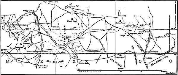 |
| Map Showing Route of U. S. Military Telegraph Line, Arizona. |
From this point the military telegraph line connects with the commercial system of the country, which readies all posts and department headquarters.
The matter of observing Indian trails is one of the most difficult problems the troops have to contend with; and really can only be satisfactorily done by Indian scouts enlisted in the service of the United States from the peaceful tribes. A band of hostiles crossing a rugged mountain over rocky cliffs generally leaves no marks that are observable to the eye of a soldier, but to the Indian scout the turning of a rock, or the disturbance of the slightest object on the ground, seems as an open book. He not only knows therefrom the time intervening between the disturbance of the object and the moment at which he observed it, but the number of the band and whether their movements were slow or rapid can be told.
The Signal Corps has, since 1873, maintained long stretches of military telegraph lines; but when commercial lines parallel them, usually along new railroads, the military lines give way, or, as frontier posts are abandoned, the military lines thereto are taken down. The post of Fort Stanton, New Mexico, near the Mescalero Apache Indian Reservation, was abandoned nearly a year ago, and the military telegraph line connecting that post with the railroad wires at Carthage and San Antonio, New Mexico on the Santa Fe Railroad was taken down and the material stored. Out of this material a new telegraph line was built this summer from Fort Grant to Mammoth, Ariz., to aid in intercepting hostile renegade Indians; and from the remaining material the line from Bisbee to San Bernardino, Ariz., has just been built. Military telegraph lines are built of tubular iron poles about 20 feet in length and nearly three inches in diameter, each weighing 72 pounds; ordinary No. 9 wire is also most frequently used.
Bisbee is situated in the Mule Mountains and is the location of the great Copper Queen mine (see map). The owners of the mine have a railroad, with telegraph line, 55 miles in length, to Benson on the Southern Pacific Railroad. The "Stilt City" as I have heard it called, would be a more appropriate name for Bisbee, for the town is built on the sides of a narrow canyon and the houses are upon terraces on the mountain sides, the front of many houses being held up by timbers where the slope sometimes is 30 degs.
The difficulty of approach for wagons to the railroad station at Bisbee made it advantageous to place the military wire on the poles of the railroad line, which was done to Don Luis station 4 miles from Bisbee down the mountain and outside the canyon. At Don Luis, therefore, the telegraph material was unloaded from the cars, to be carried thence by army wagons to its place of erection. From Don Luis there is a gradual downward slope to tne Mexican boundary, and the telegraph line was built from that station to the U. S. Custom House on the Arizona-Mexico boundary in a direct line six and onequarter miles. From the Custom House a direct line east, twenty-four miles in length, was built, parallel to and 200 yards north of the boundary monuments, which latter are placed along the United States-Mexican boundary at irregular intervals, several miles apart, but always so placed that the monument on either side of the one at which an observer stands is visible. This line of poles in perfect alignment passed almost due west over a spur of the Mule Mountains into the south end of the Sulphur Spring Valley; the end of this stretch of 24 miles of line being at the base of the Niggerhead Mountain, a conspicuous peak in the Swisshelm range. At the latter point the line had to make an angle so as to nearly follow the winding road which was made along the trail as we progressed through these mountains; and two additional curves were necessary as we emerged from those mountains. San Bernardino, which is only a very extensive cattle ranch, was then in sight, nine miles distant, and to that point another straight une of poles was erected. It will be seen that the line consists of 5 tangents, 2 angles and 2 curves; and is about 40 miles in length from Don Luis. Its erection was considerably retarded by unusually heavy rains which resulted in floods that made the trail impassable for our wagons; but, notwithstanding this, the line was entirely completed between the commencement of work on October 15, and November 10. The route of the line is shown on the accompanying map. To erect such a line over such a country and transport the necessary material and supplies there were detached from troops at military posts 2 sergeants of the Signal Corps and 31 men, with one Indian scout for guide; also, two six-mule wagons, two four mule wagons and seven horses. The equipment of tools consisted of digging bars, picks, shovels, axes, blasting material (as we occasionally had to use dynamite to blast holes for the poles), and the usual line working appliances. The detachment was divided into gangs for surveying and staking, digging holes and erecting poles, and stringing the wire. The bulk of the labor, such as the digging, was done by colored troops, who constitute the best possible force for doing work entailing hard manual labor. The effort was made to keep the gangs closely together; and if the work of one gang advanced more than that of another men were taken from the former and put with the gang which was falling behind. This enabled a constant personal supervision and oversight of the work of each party to be kept up by the officer in charge. Under a conjunction of favorable conditions there was erected in the lower Sulphur Springs Valley during one day five miles of completed line the entire work of surveying the line, digging the holes, erecting the poles, etc., having been done that day. It should be remembered that over this stretch of country there was no road only an occasional trail. As the work progressed, however, trimmers with axes advanced with the surveyors and cut a swath in the chapparal of sage brush and mesquite which covers the whole of Arizona. Our wagons in hauling and distributing the material along the line so trimmed out soon made a highway, which is now being used by troops, etc., traveling that way.
The want of water was one of the serious drawbacks, as streams or water holes are only found at long intervals. Kegs were supplied, and in these water was carried with the working parties as they progressed; and whenever far from a water supply dry camps had to be made dependence was had entirely upon water so carried. Ten ten-gallon kegs were available for this use. Under such circumstances not much was used for personal ablution.
In building this telegraph line it was deemed best to lay it out carefully, hence a surveyor's transit was used, and stakes set beside each point selected for placing each pole. The pole raisers by setting the poles accurately on the line of stakes were able to preserve a perfect alignment. By such long tangents and perfect adjustment to a straight line, as the poles could be thus placed farther apart, there resulted an economy in material; and, as there is less strain on a line when it is straight, there will be less chance of interruption in the working of the line. The latter is an important feature where a line passes through stretches of uninhabited country.
The wire for this line having been before used, and in taking down the old line the wire having been coiled in bundles of different sizes, it was found that the collapsible reel known as the "Little Giant" was of great availability in that particular feature, as it is capable of handling coils of varying diameter. In this matter of the reel there is an illustration of the peculiar fact of the frequent development by different persons of a similar idea or invention. When the line between Fort Stanton and Carthage was about to be taken down, the necessity of a collapsible reel appealed to the writer, who set to work to design one. One day while the reel so designed was being constructed, on going into a hardware store to purchase some bolts there was found the advertisement and picture of the "Little Giant'' reel. Its similarity to the writer's design was remarkable it was almost identical.
There was used for boring pole holes another device, entirely new, as far as known. It consisted of a hardened steel cone 6 inches long from apex to base, the base being 3 inches in diameter a trifle larger than the diameter of the iron poles; screw flanges of a boring bit similar to those on the point ot an auger were made upon the cone surface. Into the base of the cone was fastened an iron bar about 4 feet long, at the end of which bar was placed a handle similar to that of an auger. In ground devoid of gravel, this ground-boring-bit could be screwed down into the earth, and the soil, instead of coming up as in the case of an ordinary auger, was compressed all around the hole as the auger bit was driven down. Holes thus made would receive the pole snugly, and the compression of the soil under the ground served to make the pole firm and much more stable than when the hole was dug and then the loose earth thrown in and tamped. In some soils such a boring bit would be invaluable for such work, for a hole can be made in a short time with a minimum of labor.
These military telegraph lines serve an important purpose not only in aiding to prevent marauding raids of Indians but also as a means of promoting the business interests of the sections through which these lines run, as a channel of quick and cheap communication. It is the policy of the Signal Corps to charge only a nominal rate for business telegrams, consequently a great impetus to settlement, and to mining interests, has frequently been given thereby.
