[Newspaper]
Publication: The Muncie Daily Times
Muncie, IN, United States
vol. 27, no. 58, p. 1, col. 2-4
MAP SHOWING TERRITORY FROM WHICH
MUNCIE'S GAS SUPPLY IS DRAWN
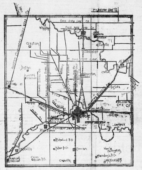 |
The above map of Delaware county gives an idea of the drain being made upon the Muncie gas field. The greatest supply is directly north of this city, as the number of lines indicate. Gas lines follow the direction of the most gas. All of the territory adjacent to these lines, which might be developed is now under lease. A glance at the map shows how the great foreign pipe-line companies have encroached on Muncies territory. An Indianapolis company has a line cutting the northwestern part of the county. The Chicago company has a line touching the field on the northwest. The Ohio pipe-line company, the relative of the Standard Oil Company, has several lines entering the field from the east. The Ft. Wayne company enters the northeastern section. Local manufacturers and gas companies are restrained within a limited territory by the leases of the foreign companies. On the map are shown the pumping stations of the foreign companies against which local manufacturers have asked State Inspector Leach to proceed, in order that as much gas as possible may be kept within this territory.